
Satellite Report Reveals Possible River Diversion Works at China’s Medog Dam Site Upstream of Arunachal
EarthSense Labs' 18-page assessment documents land clearance and possible river diversion works at Mainling, identifies Pai as a potential lower-dam location and traces years of infrastructure development near a proposed tunnel outlet close to the India-China border.
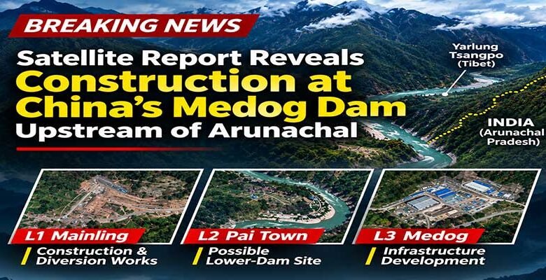
PASIGHAT ( By Maksam Tayeng )- Satellite imagery analysed by Indian geospatial firm EarthSense Labs indicates significant construction activity, land clearance and possible river diversion works at Mainling in Tibet, where China formally launched its ambitious Medog hydropower project in July 2025. The findings also document years of infrastructure development near a proposed tunnel outlet close to the India-China border, raising fresh questions about the scale and progress of the project on the lower Yarlung Tsangpo River, which enters Arunachal Pradesh as the Siang and flows through Assam as the Brahmaputra.
In its 18-page EarthSense Discovery Report, titled Building at the Great Bend: Monitoring China’s 60 GW Medog Dam Project, the company presents a satellite-based geospatial intelligence assessment of construction activities at three identified locations along the river system.

China’s proposed Medog hydropower project is planned as a cascade of five hydropower stations along the lower Yarlung Tsangpo, with a reported installed capacity of 60,000 megawatts (MW). The project has an estimated investment of 1.2 trillion yuan, equivalent to approximately US$168 billion at the time of its announcement. The proposed infrastructure is expected to exploit the river’s substantial elevation drop through a system of dams, tunnels and multiple power stations.
Mainling: Land clearance and possible river diversion works
One of the report’s major findings concerns the Mainling High Dam location, identified as L1 in its geographical assessment.
Comparing satellite images from July 11, 2025, December 4, 2025, and August 10, 2026, EarthSense documents substantial changes around the proposed construction site.
According to the assessment, villages and agricultural fields were visible on the south bank before the project’s groundbreaking ceremony on July 25, 2025. Subsequent imagery shows land clearance, removal of agricultural fields and earthwork activities.
By August 2026, the imagery showed extensive road development on the north bank, additional site infrastructure and what EarthSense identifies as river diversion works.
The company states that upstream villages and agricultural fields on the south bank had been removed, while new roads, concrete structures and makeshift buildings had appeared on the north bank.
River diversion is generally undertaken to redirect water around a construction site, allowing work on the main dam structure to proceed. However, the satellite assessment does not independently establish the complete engineering design or operational arrangements of the proposed diversion system.
Pai: Possible location of a second dam
The report also identifies Pai town as a possible lower-dam location, designated L2.
However, EarthSense makes an important qualification regarding the site. A comparison of satellite imagery from October 2025 and October 2026 found no conclusive evidence of structural construction at the identified location.
The company suggests that development could potentially begin from the lower tunnel end, identified as L3, rather than from the Pai location.
The proposed role of Pai in the overall hydropower system remains an assessment by EarthSense and should not be interpreted as confirmation of an officially established construction site.
L3: Years of infrastructure development near the proposed tunnel outlet
Another significant finding in the report concerns L3, an area near the India-China border that EarthSense associates with the proposed downstream tunnel outlet.
Unlike the recent construction activities documented at Mainling, the satellite assessment traces infrastructure development in this area over several years.
According to the report, road construction along the river was already visible in April 2018, when only a small community was identified in the surrounding area.
Further imagery shows additional groundwork during 2019–2020, followed by residential and industrial development by 2021. A bridge construction timeline presented by EarthSense indicates that work began in 2020 and was completed by 2021.
The report further identifies approximately 30–35 new residential and industrial buildings appearing during 2023–2024.
One of the notable developments was the establishment of a concrete batching plant. Comparing satellite imagery from April and August 2024, EarthSense identifies the clearing of forested land and the subsequent appearance of the industrial facility.
Imagery from 2024 and February 2025 also shows additional industrial buildings, vehicles, concrete-mixing facilities and an expanding network of roads leading towards the river.
EarthSense’s assessment suggests that these developments are relevant to the proposed tunnel outlet infrastructure. However, the report does not conclusively establish that every identified facility was originally constructed exclusively for the Medog hydropower project.
Potential implications for downstream river systems
The proposed hydropower infrastructure has potential implications for communities and ecosystems downstream in Arunachal Pradesh and Assam.
EarthSense notes that reservoir filling schedules and water releases for electricity generation could influence the timing and volume of downstream flows, particularly during the dry season.
Large reservoirs can also retain sediment that would otherwise move downstream. Changes in sediment transport could have implications for river morphology, floodplains and agricultural systems.
The actual extent of any downstream impact would depend on reservoir capacity, operating arrangements, water releases and contributions from tributaries below the project.
The report, however, does not provide a detailed hydrological model or quantified projections of changes in water levels, sediment movement or flood risks in India.
The region has previously experienced the consequences of sudden upstream natural events. In June 2000, a landslide blocked Tibet’s Yigong River, a tributary of the Yarlung Tsangpo. When the natural barrier breached, the resulting flood travelled downstream into Arunachal Pradesh and affected the Brahmaputra river system.
The incident highlighted the importance of timely upstream hydrological information, cross-border monitoring and effective early-warning mechanisms.
India’s concerns over access to such information have also been documented. The Indian government informed Parliament in 2025 that China had suspended the supply of Brahmaputra hydrological data in June 2023 following the expiry of the bilateral data-sharing arrangement. New Delhi subsequently sought the resumption of data sharing.
Medog project and opposition to Arunachal’s proposed Siang dam
The satellite findings emerge amid continuing opposition to the proposed 11,200-MW Siang Upper Multipurpose Project (SUMP) in Arunachal Pradesh.
The proposed project has faced resistance from sections of the Indigenous Adi community, particularly over concerns relating to displacement, loss of ancestral land, agricultural livelihoods and the future of settlements along the Siang valley.
Survey and drilling activities associated with the pre-feasibility study have triggered protests, with demonstrators questioning the consultation process and the potential consequences of a large reservoir.
The Siang Indigenous Farmers’ Forum has alleged that affected landowners were excluded from consultations. Protests in Pasighat turned violent on October 23.
The state government, meanwhile, has argued that a reservoir on the Siang could help manage sudden changes in upstream river flows and strengthen preparedness against potential water-related risks.
However, the extent to which the proposed project could address risks associated with China’s upstream hydropower infrastructure remains a subject requiring detailed technical examination.
Questions remain over India’s preparedness
EarthSense Labs’ satellite assessment provides a closer look at construction activities along the lower Yarlung Tsangpo, particularly at Mainling and near the proposed tunnel outlet.
While the imagery documents significant infrastructure development, several questions remain regarding the final engineering configuration, the proposed tunnel alignment, reservoir operations and the possible consequences for downstream communities.
The identification of Pai as a potential lower-dam location, together with the years of infrastructure development documented near L3, adds further dimensions to the understanding of the proposed project.
For Arunachal Pradesh and Assam, the developments underline the importance of reliable hydrological data, independent scientific assessments, cross-border river monitoring and effective disaster preparedness.
As communities in Arunachal Pradesh continue to debate the proposed Siang project, the larger question remains how developments upstream in Tibet could affect the river system on which millions of people downstream depend.
Source: EarthSense Labs – Medog Dam Discovery Report
EarthSense Labs, Building at the Great Bend: Monitoring China’s 60 GW Medog Dam Project, Discovery Report ID: EDR-2026-BRAHMA-323-P. The satellite observations and interpretations cited in this report are attributed to EarthSense Labs.